
What is METT-TC Part 4: Terrain and Weather
Published August 18, 2023
This month, Michael works through the first T in METT-TC using the acronym KOCOA-W. Check out the article below for an in-depth breakdown of each of the KOCOA-W elements as well as resources for further reading.
Terrain and Weather (METT-TC)
Terrain and weather considerations highlight the need to apply mission variables to both your plan and the enemy's plan. Let's say that the enemy has a position in a low-ground area, or perhaps, as is common here in middle Tennessee, a flood zone. Unfortunately for them, they occupied the position during temperate weather with little to no precipitation and started to dig an elaborate trench system with various fighting holes. They discover their fatal mistake when a large rainstorm rolls through the area for the next several days. Think of how miserable and inattentive the enemy will be during that time while their trenches are flooding—the need to constantly bail out water or dig pathways to direct water out and away, the inability to get any form of decent rest, and the poor visibility that is likely to accompany such a storm are just some of the factors that could lead to poor observation and reduced security postures.
All these factors are significant and can be leveraged if you know how to deal with them. It may be an extremely advantageous time to enact your plan while the enemy is focused on environmental factors, but you must always keep in mind how these factors will affect your plans and your personnel. You may be just as miserable and bogged down as the enemy in these conditions. Do you have thermal that will allow you to at least observe through the downpour? Thermal will not be as effective as it could be in clearer conditions, but it will be significantly better than the unaided eye. Do your troops have clothing to address the weather concern? Have they trained or operated in these types of conditions before? Are they disciplined enough to carry out the plan, or will creature comforts take over?
KOCOA-W
To address the factors of Terrain and Weather, I use the acronym KOCOA-W. Other variations that are presumably more common due to use by the US Army are OAKOC and OCOKA. I still stick with a KOCOA-W for two reasons: 1) It's how I was taught, and 2) adding the W on the end keeps Weather attached to the acronym, ensuring it is still considered. Of course, you could add a W to the other variations if you heard those first and want to remember them via your preferred acronym. I realize neither of my reasons is compelling, so use whatever you like or whatever your command/organization uses so everyone is on the same page.
Before breaking each variable down, I do want to note that the acronym order doesn't necessarily dictate the order in which you should work through the acronym. As I go through this phase of the planning process, I may skip around, but will always go back over each variable to make sure I fill them in once I have solid answers. Check out the video above to see the order I prefer to work through KOCOA-W.
Key Terrain (KOCOA-W)
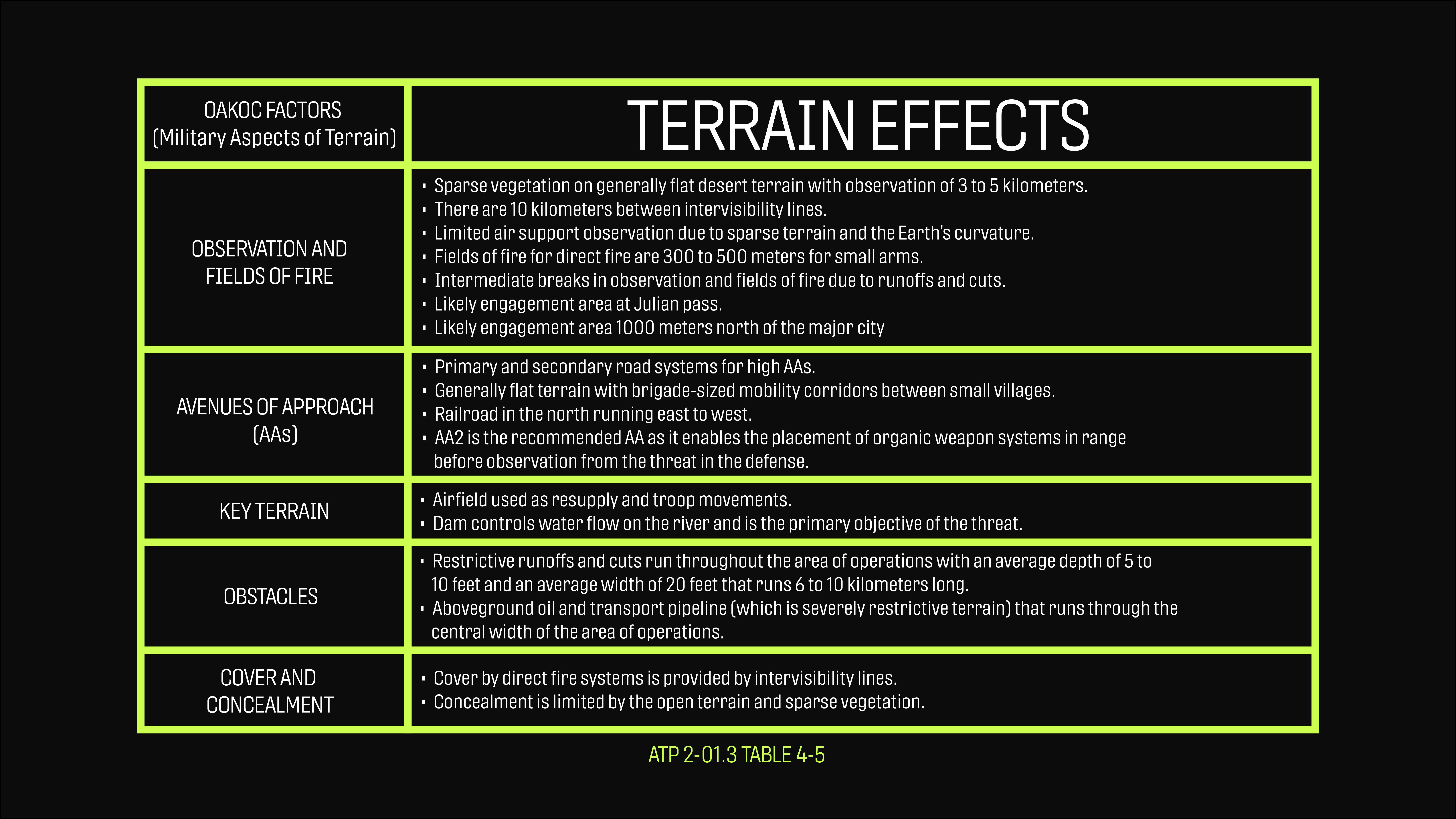
Key Terrain is any locality or area, the seizure or retention of which affords a marked advantage to either combatant (JP 2-01.3). In other words, if you (or the enemy) were to physically occupy or control a specific area, you would retain a considerable advantage. The classic example, and the easy answer, is a hilltop—it affords good observation, and with that typically comes good fields of fire. But if that hilltop is nowhere near anything important, then it isn't key terrain. So, resist the urge to label every hilltop as key terrain.
Observation and Fields of Fire (KOCOA-W)
From what I have seen, some people teaching KOCOA generally just state "observation" and tend to miss the second component, fields of fire. Observation is straightforward—what areas on the terrain afford you good observation or lines of sight? However, there is a reason fields of fire is also included here. Not only do you want to cover the area of interest by sight, but it is important to figure out how well you can cover it with direct-fire weapons or whatever organic weapons you may have. You can get into the weeds quickly here and do a LOS (line of sight) analysis, which can help identify dead space (space that offers cover from direct fire weapons, typically defilade). Another way to think about the point I am trying to make here is to ask yourself, "If I were to emplace at this spot, would I have a usable range card?" I know that may seem obvious to many, but considering if you can cover an area with both your eyes and your weapon should always go hand in hand.
Cover and Concealment (KOCOA-W)
We've all heard it by now, but let's quickly define cover and concealment:
- Cover: Physical protection from fire. The types of fire, whether small arms, direct, or indirect, will influence what is considered cover. Put simply, cover stops bullets.
- Concealment: Protection from observation.
With current technology, it is wise to consider Cover and Concealment from both ground and aerial threats.
There is a saying that you can't shoot (or hit) what you can't see. While true for small arms, if the enemy uses other weapon systems that produce fragmentation, you will still want to strongly consider cover. Cover can be concealment as well. For instance, if you are behind a brick building opposite the enemy, you are both covered from their fire and concealed from their observation. However, concealment does not mean you are covered, i.e., hiding in a row of bushes or lying prone in tall grass.
With that out of the way, what should you be factoring in when you are analyzing the terrain? I recommend doing this step only after you have identified Key Terrain and Avenues of Approach. Then, you can look at what areas and potential Approaches to and from the Key Terrain feature(s) will offer some type of cover and/or concealment. This is useful for taking or defending Key Terrain and goes hand in hand with Observation and Fields of Fire. And remember, you should attempt to analyze Cover and Concealment for both friendly and enemy forces.
Obstacles (KOCOA-W)
Obstacles can be natural, artificial, emplaced, existing, etc. In the grand scheme of things, it isn't that important to classify the type of obstacle—what is important is that you understand the effect an obstacle has on you, the enemy, and anyone else in the area.
Formally, obstacles have a funneling effect, limit maneuverability, or canalize troop movements. They can fix, turn, delay, or disrupt movement. Once I have identified Avenues of Approach (AAs), I look for obstacles along those routes. Are there any that funnel/canalize or delay/impede movement along an AA? These are areas that I want to direct my attention toward.
Avenues of Approach (KOCOA-W)
An Avenue of Approach is a route that leads to Key Terrain or an objective. This is the first thing I address when doing a terrain analysis. It could be highways, dirt roads, a field, a mountain pass, etc. Where is movement unencumbered or along the path of least resistance? You'll also need to consider the method of mobility and the accommodating size for each AA—from vehicles to foot patrols. Will the AA allow movement of a battalion (~1,000 troops), or is it more likely it only allows a platoon-sized element?
Weather (KOCOA-W)
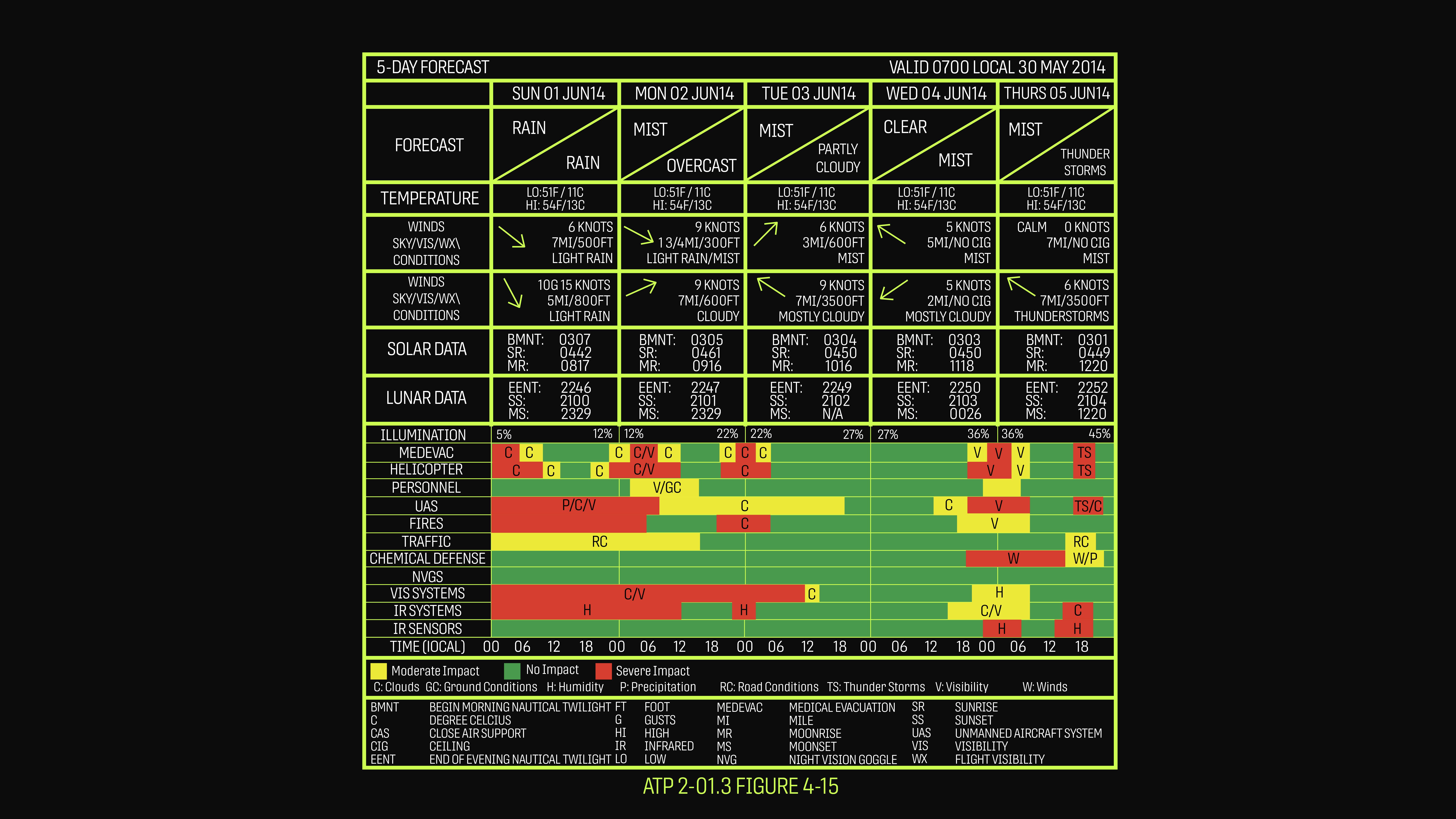
This is a huge topic and a whole other article in and of itself, as weather can completely change the situation. Terrain can become unnavigable, morale often plummets (but so does the enemy's), certain equipment becomes unusable, or more equipment must be brought just to keep everything in working order. There's a reason the US Military has weatherman as a MOS (military occupational specialty). The following is a quick breakdown of aspects of weather and how they affect military operations.
Straight out of ATP 2-01.3: The military aspects of weather are visibility, wind, precipitation, cloud cover, temperature, humidity, and atmospheric pressure (as required).
Visibility
Visibility is how far you can see and identify objects with the unaided eye. The largest, most direct effect on visibility is illumination. This is where we consider solar and lunar data.
For each of these points, a time is assigned, which will aid in planning when certain actions can occur. These times should also be briefed so that your personnel will understand when heightened security should occur (typically called a Stand To) as well as when night vision devices should be prepped for use.
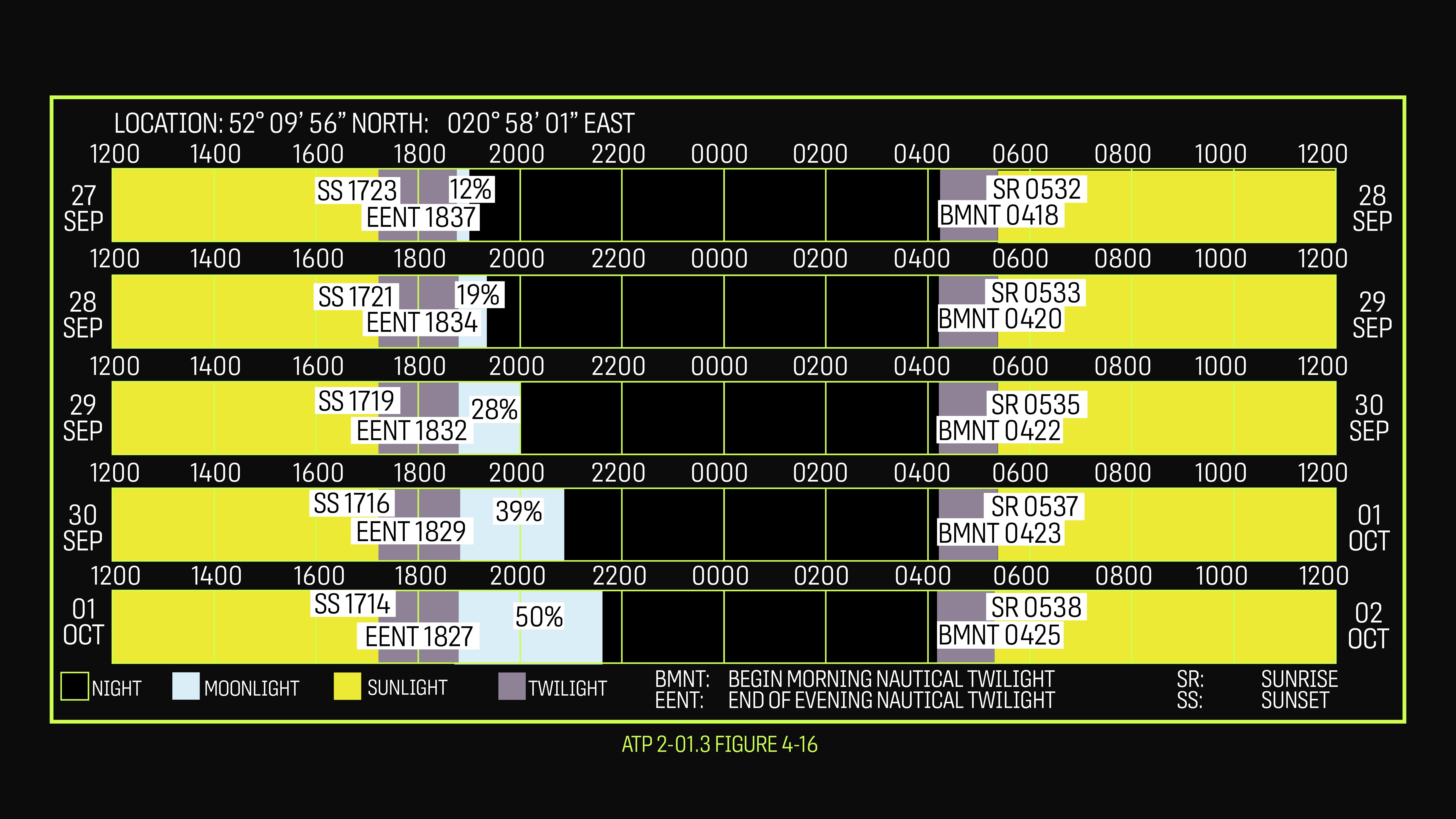
Begin Morning Nautical Twilight (BMNT)
This is the point in the morning where you can start to make out objects with the unaided eye, and limited military operations without night vision become possible. Night vision is still an advantage in this amount of illumination.
Begin Morning Civil Twilight (BMCT)
The sun isn't up yet, but you can see clearly without night vision. Night vision should no longer be used.
Sunrise
The sun rises above the horizon.
Sunset
The sun sets below the horizon.
End Evening Civil Twilight (EECT)
There is still enough usable light to conduct limited military operations with the unaided eye. Night vision should be considered.
End Evening Nautical Twilight (EENT)
Once this period ends, there is no sunlight available for control of military operations. Night vision is required.
Moonrise
The time when the moon rises above the horizon. You will also want to consider the moon phase and % illumination.
Moonset
The time when the moon sets below the horizon.
Of course, more than just solar and lunar conditions can affect visibility. Cloud cover can greatly impact visibility, especially at night, and precipitation can easily obscure visibility as well.
In general, low visibility favors offensive elements (think concealment while maneuvering) but negatively affects defensive elements, reconnaissance, and target acquisition (conducting observation is restricted).
Wind
Wind has a strong effect on aerial/aviation tasks. Additionally, if you are into precision shooting, how much more difficult does a shot become on a windy day versus a calm day? If you are in a desert environment, sand and dust being kicked up by strong winds can be brutal, and you'll likely have to ensure any electronic devices are well protected.
Precipitation
Rain, hail, or snow—precipitation can have a massive effect on your plan. Some equipment simply may not function properly, terrain can suddenly become an obstacle, and personnel will say things like, "If it ain't rainin' we ain't trainin," but deep down, they are miserable.
Cloud Cover
This is another aerial/aviation-heavy consideration. However, low clouds and fog can impact ground forces just as much. If you want to learn more about the implications of cloud cover and cloud ceilings regarding drones or other aerial observation capabilities, I highly recommend checking out the videos and podcasts that S2 Underground has put out on the topic.
Temperature
Extremes in temperatures can greatly affect personnel and equipment. It's no surprise that planning will look very different in a freezing environment versus a hot and dry desert versus a hot and humid jungle. Something to keep in mind if you (or the enemy) employ thermal devices is a phenomenon known as thermal crossover, which generally occurs twice in a 24-hour period. Thermal crossover occurs when an object and the ground are similar enough temperatures to make an object difficult to distinguish against its background. These crossover periods generally occur during the transition from night into day and day into night.
Humidity
Here in Middle Tennessee, we get our fair share of summer humidity. This can affect equipment as well as your body's ability to cool itself. Additionally, understanding temperature's relationship to relative humidity and dew point will indicate if conditions can turn foggy, which will have a large effect on visibility.
Atmospheric Pressure
Another large factor for aviation operations. Atmospheric pressure can affect lift capacity, especially for helicopters.
To sum it up, terrain and weather have massive effects. They shape what is and isn't possible. Severe weather can completely stop an operation, and impassible terrain can grind a battalion to a halt. So, check your forecasts (maybe cross reference a few), understand your terrain (study a topographic map, satellite imagery, etc.), and you will be lightyears ahead of most people.
I highly recommend you continue digging into this topic since there is so much more to cover. Here are some excellent resources for you to continue your research:
ATP 2-01.3 Intelligence Preparation of the Battlefield (March 2019)
ATP 3-34.80 Geospatial Engineering (February 2017)
MCRP 12-10B.1 Military Operations on Urbanized Terrain (April 2018)
As always, email us at [email protected] if you have any questions or comments.